Our Projects
For over 46 years, DexBender has assisted both private and public entities in the successful completion of a variety of projects.
-
![]()
Brightwater
Brightwater is a 750 acre, 1,300 unit single-family residential development which includes a six acre lagoon. DexBender’s scope of services for the project includes Vegetation Mapping, Protected Species Assessments, Zoning, Development Orders, South Florida Water Management District (SFWMD) permitting and monitoring, U.S. Army Corps of Engineers (COE) permitting, Gopher Tortoise Relocation, and General and Heritage Tree Surveys.
-
Single Family Mangrove Trimming
This scope of services includes pursuing a Florida Department of Environmental Protection (DEP) Permit to trim mangroves, and the supervision of mangrove trimming per the DEP requirements. Includes permit application submittal and answering agency sufficiency questions to final agency action.
-
![]()
Bowman's Beach Gopher Tortoise Relocation Site
The Lee County Parks and Recreation identified Bowman’s Beach on Sanibel Island as a possible relocation site for gopher tortoises occurring on land slated for future development. DexBender (an Authorized Gopher Tortoise Agent) assisted Lee County with the process of obtaining Florida Fish and Wildlife Conservation Commission (FWC) approval of the 65.8 acres of habitat as a Gopher Tortoise Recipient Site with Long Term Protection. This consisted of conducting gopher tortoise burrow surveys and vegetation sampling, preparing the application, and negotiating the terms of the permit with the FWC. We are also conducting annual gopher tortoise surveys in order to track the gopher tortoise population as gopher tortoises are relocated to the site.
-
![]()
Pink Shell Docks
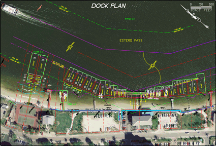
DexBender was the consultant for the refurbishment of a 41 slip docking facility associated with an existing resort hotel. The scope of services for the project included Florida Department of Environmental Protection, U.S Army Corps of Engineers, and town of Fort Myers Beach permitting as well as coordination with Florida Fish and Wildlife Commision, U.S Fish and Wildlife Service and National Marine Fisheries Service. Additional services provided included data collection for hydrographic analysis and a benthic resource survey of the project area.
-
![]()
Bowditch Point Public Docking Facility
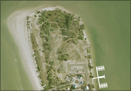
The Bowditch Point public docking facility consists of a multi-slip, transient, public docking facility located on the northern end of Fort Myers Beach. DexBender scope of services included a benthic survey of the proposed site, Florida Department Of Environmental Protection and U.S. Army Corps of Engineers permitting, as well as coordination with the Florida Fish and Wildlife Conservation Commission and the United States Fish and Wildlife Service. We successfully completed the permitting of the facility in March, 2006.
-
![]()
Caribbean Cove
Caribbean Cove is a 31 unit single-family residential development which includes 32 wet slips and associated docking structures located within an existing canal adjacent to the Caloosahatchee River. The project also includes an observation pier which extends into the Caloosahatchee River. DexBender’s scope of services for the project included U.S. Army Corps of Engineers (COE), South Florida Water Management District (SFWMD), and Lee County permitting as well as coordination with National Marine Fisheries Institute, U.S. Fish and Wildlife Service, and Florida Fish and Wildlife Commision.
-
![]()
Argo Ranch
Gopher tortoise and scrub jay surveys were conducted in a variety of habitats including palmetto prairie, pine flatwoods, scrubby pine flatwoods, and xeric scrub on this 1,726 acre property. The survey documented the presence of over 700 gopher tortoise burrows and one scrub jay family. These results facilitated the preparation of a site plan that allowed both of these listed species to be retained on-site in a vegetatively diverse 139 acre preserve.
-
![]()
Hamilton Greens
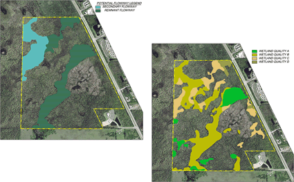
The Hamilton Greens parcel located in Collier County contained jurisdictional wetlands and scattered gopher tortoise burrows in the uplands. We worked with the development team to devise a site development plan which impacted the lowest quality wetlands along Livingston Road while enhancing a wetland flowway towards the back of the property. We prepared a Collier County Environmental Impact Statement and successfully responded to all of County environmental staff’s concerns with the project.
-
![]()
Indian Fields Transmission Line Replacement
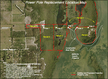
The project involved the replacement of five power poles located within the Matlacha Pass Aquatic Preserve (MPAP) which were damaged during Hurricane Charlie. Four of the power poles were located within mangrove wetlands and one of the poles werelocated at the base of a Native American archaeological site. Given the historic and ecologically sensitive nature of the project, it was necessary to coordinate with the MPAP and the Florida Division of Historic Resources in addition to the Florida Department of Environmental Protection, U.S Army Corps of Engineers, Florida Fish and Wildlife Commision, and U.S Fish and Wildlife Service. In order to avoid impacts to mangrove wetlands, a helicopter was utilized during installation of the poles and associated caissons. Installation of the power poles was completed in March of 2009 with minimal or no impacts to cultural or environmental resources. In addition to the permitting services, DexBender also provided water quality monitoring during installation of the power poles and continues to provide environmental monitoring of the installation sites.
-
![]()
Orange River Landing
Orange River Landing is a multifamily residential development which includes a 48 wet-slip docking facility with direct access to the Caloosahatchee River. Services provided by DexBender during the permitting process included a protected species survey as well as a benthic survey of the docking facility site. Additional services consisted of South Florida Water Management District (SFWMD), U.S. Army Corps of Engineers (COE), and Lee County permitting including coordination with the National Marine Fisheries Service, Florida Fish and Wildlife Conservation Commission, and the United States Fish and Wildlife Service. In order to meet water quality requirements, a planted flushing shelf was proposed within the marina basin which was designed to increase tidal flushing and also provide additional treatment of stormwater discharge. The project received SFWMD and COE permits in 2009. Lee County authorization for the project is pending.
-
![]()
Porpoise Point Multifamily Dock
The Porpoise Point multifamily docks consist of a mulit-slip, private docking facility located in the Matlacha Pass Aquatic Preserve. Our scope of services included a benthic assessment of the proposed site, South Florida Water Management District and U.S Army Corps of Engineers permitting, as well as coordination with the Matlacha Pass Aquatic Preserve, United States Fish and Wildlife Service, Florida Fish and Wildlife Conservation Commission, National Marine Fisheries Service and Lee County environmental staff. Public concerns were also addressed by DexBender during the permitting process. In order to minimize impacts to benthic resources, the portion of the dock which passed over seagrass was elevated and constructed of a grated material which allows sunlight penetration.
-
![]()
Saint Charles Yacht Club
DexBender was contracted to permit the addition of two wet slips within an existing docking facility located adjacent to the Caloosahatchee River. The scope of services included U.S Army Corps of Engineers and Florida Department of Environmental Protection permitting along with coordination with Florida Fish and Wildlife Commision (FWC), U.S Fish and Wildlife Service, and National Marine Fisheries Service. Based on the linear feet of applicant owned shoreline at the existing facility, the addition of the two slips did not meet the requirements of the Lee County Manatee Protection Plan. In order to make the project permitable, DexBender coordinated with Lee County and the FWC in order to complete the first ever transfer of slip credits from an offsite donor parcel.
-
![]()
Tarpon Point Marina
Tarpon Point Marina is a 175 wet-slip docking project which included dredging of sovereign submerged lands and relocation of an existing fuel dock. Our scope of services included a benthic assessment of the proposed site, data collection for hydrographic analysis, South Florida Water Management District and U.S Army Corps of Engineers permitting, as well as coordination with the United States Fish and Wildlife Service and the Florida Fish and Wildlife Conservation Commission. Because the project is located in an area which was designated critical habitat for the smalltooth sawfish during the permitting process, it was necessary to quickly redesign the project based on coordination with the National Marine Fisheries Service.
-
![]()
Winkler 10 Acre RPD
The County re-zoning of this property from agricultural zoning to a zoning allowing for an assisted living facility use was complicated by a bald eagle nest in an Australian pine tree near the center of this ten acre property. The majority of the site was also wetlands vegetated by exotic plants that would have to be removed from the site at the time of development. We monitored the eagle nest to determine the direction of the eagle’s flight paths and used that information to work with County staff to prepare a bald eagle nest management plan based on a phased removal of exotics and supplemental plantings which allowed the land owner reasonable use of the property while providing protection of the eagle nest. The management plan was approved by the Lee County Eagle Technical Advisory Committee and the requested re-zoning was approved by both the Lee County Hearing Examiner and the Lee County Board of County Commissioners.
-
![]()
Zemel Property Cape Coral Comprehensive Plan Amendment
The City of Cape Coral annexed the 1,121.8 acre Zemel property and initiated the process to amend its comprehensive plan to incorporate an appropriate land use classification for the annexed lands. Based on comments received from the Florida Department of Community Affairs, we conducted field investigations in order to provide additional detailed information concerning vegetative communities, flowways, the extent and function of state jurisdictional wetlands, and potential habitat for listed species on the property. The results of our investigation were utilized by the City and the project team to delineate the locations of future potential development areas while creating a conservation land use category to protect interconnected areas of ecologically significant habitats.


